Haboobs, chinooks and derechos: regional weather hazards by name
Early in the afternoon of July 4, 1999, a line of thunderstorms crossed the canoe country of northern Minnesota with winds estimated at 80 to 100 mph (130 to 160 km/h). In a few minutes it flattened about 600 square miles (1,550 km²) of forest. It was a holiday weekend and the lakes were full of paddlers. Sixty people in the Boundary Waters were injured by falling trees, and twenty of them had to be flown out by float plane. The storm had a name, a derecho, that almost nobody in those campsites had heard before that day.
Much of North America’s most dangerous weather is regional. It happens in one kind of country, in one season, and the people who live there have a word for it: haboob, chinook, Santa Ana, nor’easter. Visitors usually have not heard the word, and a forecast that uses it is no help to them. This guide takes ten of those names in turn. For each one it covers where and when it happens, what warning you get, what it does to someone on foot or in a boat, and what to do about it. How weather works in general, and how to get and read a forecast, is covered in reading backcountry weather.
Look up the local name before you go
When you plan a trip outside your home region, search the area’s name together with “weather hazards”, and read the local forecast office’s page for the season you are going in. If a word in the forecast is new to you, look it up before you leave. It is usually the most important word in it.
Finding the name in a forecast
Each of these hazards is forecast, most of them a day or more ahead, but the warning does not always use the name. A haboob is covered by a Dust Storm Warning. A derecho is usually covered by a Severe Thunderstorm Watch that mentions widespread damaging winds. Santa Ana and Diablo winds bring a Red Flag Warning. Lake-effect snow comes with a Lake Effect Snow Warning in the United States and a snow squall warning in Canada.
Two habits help in every region. In the United States, read the Forecast Discussion on the local National Weather Service office’s page as well as the forecast itself. It is written by the forecasters in plain paragraphs, and it is where they say that a chinook, an atmospheric river or a wind event is on the way. In Canada, read the alerts and special weather statements from Environment and Climate Change Canada for the region, which do the same job.
You can check the alerts from our park guides too. The current forecast on every park guide now leads with the weather alerts in force for that park, from the National Weather Service in the United States or from Environment and Climate Change Canada. Open the guide for the park you are heading to and choose “See the current forecast”.
On a longer trip, the forecast you left home with goes stale. A two-way satellite messenger such as the Garmin inReach Mini 2 can pull an updated forecast where there is no phone signal, and that matters most for the hazards below that arrive with little warning in the sky.
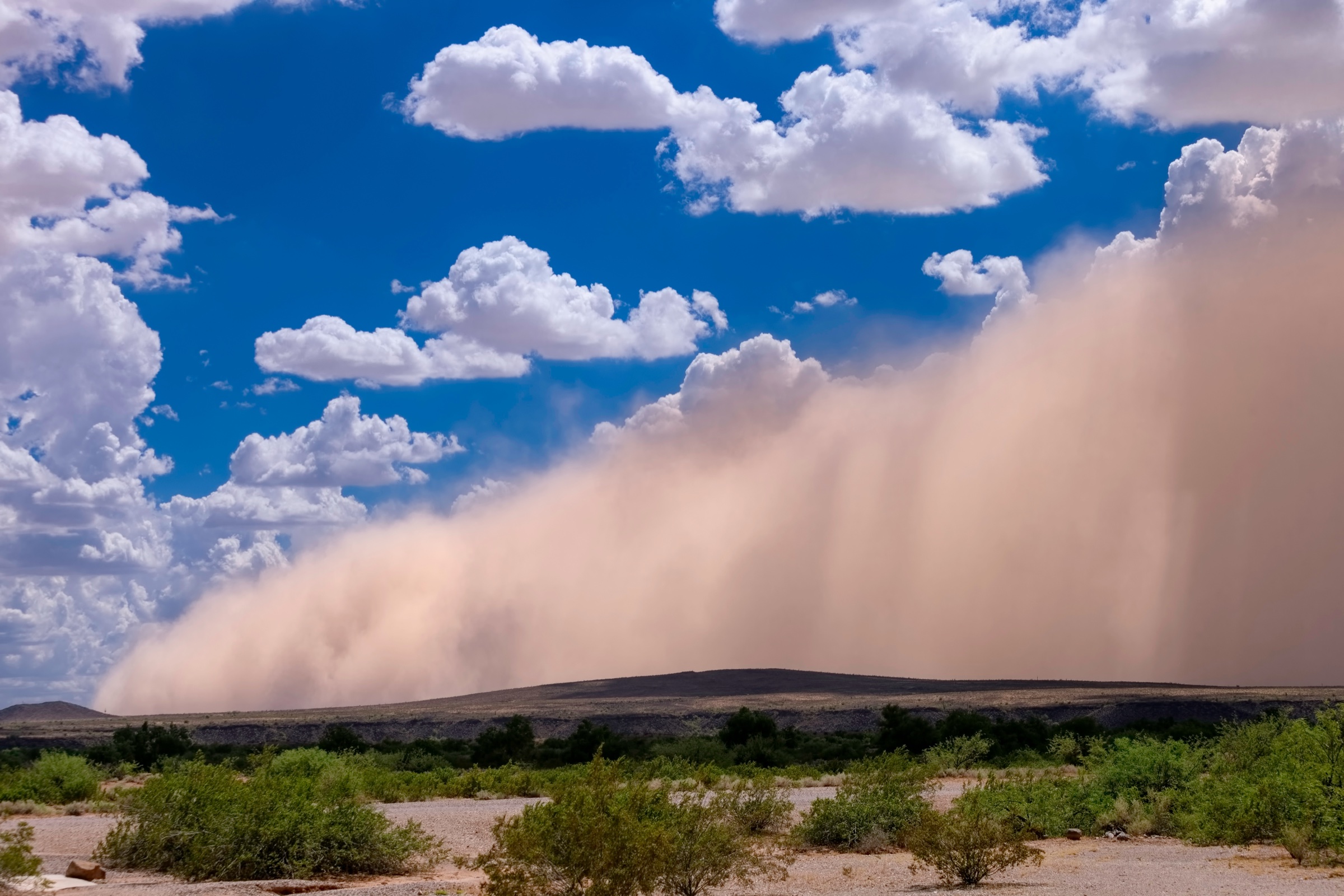
Haboob
A haboob is a wall of dust pushed ahead of a thunderstorm. Air rushing down and out from the storm lifts loose desert soil, and the leading edge travels across open country as a brown cliff. The weather service describes walls that are miles long and thousands of feet (hundreds of metres) high.
Where and when. The deserts of the Southwest, above all southern Arizona, during the summer monsoon from mid-June through September. They are most common in the late afternoon and evening, when the storms that drive them are at their strongest. The low desert around Saguaro National Park, Sonoran Desert National Monument and Organ Pipe Cactus National Monument is haboob country.
What warning you get. Very little. In open desert you may see the wall coming for several minutes. In a canyon or among hills, the first sign can be the wind.
What it does to a trip. Visibility drops to a few feet. The wind is strong enough to throw sand and small debris, and the dust is hard on eyes, lungs and anyone with asthma. The dense part usually passes in minutes, though a large one can take half an hour to clear. The more serious problem is what follows it. A haboob is the front edge of a thunderstorm, so lightning and heavy rain are often right behind, and rain on desert ground means the washes can run.
What to do. On foot, stop walking. You cannot navigate in it, and the ground you would stumble over is rock and cactus. Get out of any wash or drainage first, because of the rain that may follow, then sit with your back to the wind behind a boulder or a bank. Cover your nose and mouth with a bandana or a shirt, and protect your eyes with sunglasses or goggles. When the dust thins, apply the rules in lightning safety in the backcountry and flash floods, because that is the weather you are now in.
Driving to or from the trailhead, follow the weather service’s rule, “Pull Aside, Stay Alive”: pull as far off the pavement as you can, stop, turn off all your lights, set the parking brake and take your foot off the brake pedal. Drivers behind you steer toward tail lights, and a lit car on the shoulder gets hit.
Chinook
A chinook is a warm, dry wind that blows down the eastern slope of the Rocky Mountains. Air that has crossed the mountains sinks on the far side, and sinking air is compressed and warms, by about 5.5°F for every 1,000 feet (1°C for every 100 m) it descends. The result is a winter wind that can replace arctic air with spring in less time than it takes to pack up a camp.
Where and when. The foothills and plains east of the Rockies, from Alberta through Montana and Wyoming to Colorado, and the Black Hills of South Dakota. Chinooks happen all year, but they matter in winter. Southern Alberta is the best-known chinook country, which takes in Waterton Lakes National Park, the Kananaskis parks such as Peter Lougheed and Bow Valley, and the east side of Glacier National Park across the border.
The record shows what a chinook can do. On January 22, 1943, at Spearfish, South Dakota, the temperature rose from −4°F to 45°F (−20 to 7°C) in two minutes. Later that morning the wind dropped, and the temperature fell from 54°F (12°C) back to −4°F (−20°C) in 27 minutes.
What warning you get. Chinooks are forecast, usually by name in Alberta. In the sky, look for the chinook arch: a long, flat band of cloud lying parallel to the mountains, with a strip of clear sky between its edge and the peaks.
What it does to a trip. Three things, and the pleasant temperature makes all of them easy to miss.
- Avalanche danger rises. Rapid warming weakens the snowpack, and the wind moves large amounts of snow onto sheltered slopes, where it forms slabs. A chinook day feels like the safest day of the winter and is often one of the least stable.
- The wind is severe. Gusts above 60 mph (100 km/h) are ordinary in a strong chinook in southwestern Alberta. On an exposed ridge, that is enough to knock a walker down.
- Everything thaws, then refreezes. Snow turns to slush and soaks boots and clothing. Ice on creeks and lakes weakens, and snow bridges over creeks sag. When the chinook ends, the temperature can drop as fast as it rose, wet gear freezes, and packed trails become sheets of ice.
What to do. Check the avalanche forecast for the day of the chinook and the days after it, and treat rapid warming as a reason to stay out of avalanche terrain, as described in avalanche safety. Keep off frozen lakes and creeks during and just after a thaw; the section on ice in winter hiking explains why thaw-weakened ice is hard to judge. Pack for the cold that was there before the chinook, because it will come back, and carry traction such as the Kahtoola MICROspikes for the icy trail it leaves behind.
Santa Ana and Diablo winds
These are California’s hot, dry, offshore winds. High pressure over the interior deserts pushes air toward the coast, and it warms and dries as it descends through the mountain passes and canyons. In Southern California they are Santa Anas. Around San Francisco Bay and in the northern Coast Ranges, the same kind of wind is called a Diablo.
Where and when. The coastal mountains and canyons of California, from autumn through early spring. The dangerous ones come in autumn, before the winter rain, when the vegetation has had no water since spring. The chaparral canyons of the Santa Monica Mountains, including Malibu Creek State Park, are classic Santa Ana terrain. The strong east winds that drove the Labor Day fires of 2020 through the Oregon Cascades were the same mechanism under a different local name.
What warning you get. Plenty. These events are forecast days ahead, and the weather service issues a Red Flag Warning, which means critical fire weather is occurring or about to. During a strong event the humidity falls into single digits.
What it does to a trip. The wind itself brings heat, dehydration and falling branches. The hazard that matters is fire. In a strong Santa Ana, a fire can travel faster than a person can walk out, through brush that burns hotter than forest, in canyons with one trail and one road. Many parks and national forests close trails or whole districts during Red Flag Warnings for that reason.
What to do. Treat a Red Flag Warning as a reason to go somewhere else that day: the beach, the desert floor, or a different week. If you are already out, do not light a stove or a fire, stay off routes that follow brushy canyons or have a single exit, and leave early if you see or smell smoke. Do not wait to find out where the fire is. Park facing out, with nothing blocking the car, and check for closures before you drive, because the trails or the whole area may already be closed.
Derecho
A derecho (deh-RAY-cho) is a fast-moving line of thunderstorms that produces a band of damaging straight-line wind hundreds of miles long. The National Weather Service definition requires gusts of at least 58 mph (93 km/h) along most of the path, with scattered gusts of 75 mph (121 km/h) or more. The storms that produce them typically move at 50 mph (80 km/h) or faster.
Where and when. Mostly east of the Rockies, from May through August. The two most common tracks run from the upper Mississippi Valley southeast into the Ohio Valley, and from the southern Plains northeast. That first track covers the canoe country of the Great Lakes region. The 1999 storm crossed the Boundary Waters and the neighbouring Quetico Provincial Park, close to Voyageurs National Park, and kept going for more than 1,300 miles (2,100 km). In May 2022, a derecho travelled more than 600 miles (1,000 km) from southwestern Ontario to Quebec City in about nine hours and killed about a dozen people, most of them struck by falling trees.
What warning you get. The forecast often flags the risk in the morning. In the field, the warning is short. The leading edge is a low, dark, shelf-shaped cloud, and the Storm Prediction Center notes that because the storm moves so quickly, the time between seeing it and being in it is often too short to do much.
What it does to a trip. In forest, it brings down trees by the thousand, and falling trees are what injure and kill campers and hikers. On open water, it raises steep waves within minutes and capsizes canoes and small boats. Afterwards, trails and portages can be buried under a tangle of trunks that takes hours to climb through, and a route that took two days going in can take five coming out.
What to do.
- Before the trip, choose campsites with the overhead scan in choosing a safe backcountry campsite: no dead trees or large dead limbs within reach of the tent. Do that scan every night. In a windstorm, a dead tree within reach of the tent is the most likely cause of injury.
- On a day with severe thunderstorms forecast, stay close to shore, keep crossings short, and plan to be off the water by early afternoon.
- When you see the shelf cloud, get off the water at the nearest landing, not the one you were heading for.
- On land, leave the tent, which protects you from nothing that falls. Move away from the tallest trees and any dead ones. Get low beside something solid that would hold a falling trunk off the ground, such as a large boulder or a thick downed log, and protect your head.
- Afterwards, check everyone for injuries, expect to move slowly, and tell someone if you can. A trip plan left with a person at home matters here, because a party cut off by blowdown is overdue and unhurt, and somebody needs to know which lakes to look on. Leave Word is our tool for that.
Dry thunderstorms and virga
A dry thunderstorm produces lightning and thunder while little or no rain reaches the ground. The rain falls from the cloud and evaporates on the way down through dry air. From below it looks like grey streaks hanging under the cloud that fade out before they reach the horizon. Those streaks are called virga.
Where and when. The interior West, from the Great Basin and the Southwest north through the Rockies and the British Columbia interior, in summer. Coastal ranges get them too. In August 2020, a burst of dry lightning started hundreds of fires across northern California, including the one that burned through Big Basin Redwoods State Park.
What warning you get. Fire weather forecasts mention dry lightning, often with a Red Flag Warning. In the field, you see a thunderstorm and feel no rain, or a few drops.
What it does to a trip. Two things. The lightning is as dangerous as in any other storm, and people take the absence of rain to mean the storm has missed them. The same strikes start fires, in dry fuel, with no rain to slow them. The evaporating rain also cools the air under the cloud, and that cold air can drop and spread along the ground as a sudden blast of wind, called a dry microburst, strong enough to flatten a tent or swamp a canoe on a calm lake.
What to do. Act on thunder, whether or not it is raining. Get off ridges and summits and follow the rest of lightning safety in the backcountry. Stake the tent fully even on a still evening. After the storm, look for new smoke. A thin column that was not there an hour ago is a new fire: note where it is, work out which way you would leave, and go if it is upwind or below you. Report it when you have a signal.
Katabatic and gap winds
These are two kinds of terrain wind that catch paddlers and campers for the same reason: they blow hard in one place while the weather a few miles away is calm.
A katabatic wind is cold, dense air draining downhill under its own weight. Glaciers and icefields produce it most reliably. The ice chills the air above it, and the air flows down the valley like water. A gap wind is air forced through a break in a mountain barrier, such as a river gorge, a strait or a mountain pass, by a difference in pressure between the two sides. The gap narrows the flow and speeds it up.
Where and when. Katabatic winds blow wherever a valley runs down from ice: Glacier Bay, Kenai Fjords, Kluane, and the glaciated valleys of the Canadian Rockies. They are often strongest in the evening and overnight, as the air cools. Gap winds occur in the same places every time. The Columbia River Gorge and the Strait of Juan de Fuca, between Olympic National Park, Juan de Fuca Provincial Park and the San Juan Islands, are the best-documented examples. On the British Columbia coast and in Alaska, cold interior air pours out through the inlets in winter as outflow winds, and locals know each one by the name of its inlet.
What warning you get. Marine forecasts mention gap and outflow winds by place. The general forecast for the nearest town often does not, because the town is not in the gap.
What it does to a trip. For paddlers, the danger is at the mouth of a valley or inlet. The water is flat as you approach, and then you cross into the wind and into steep, short waves, sometimes within a few boat lengths. Where the wind blows against a tidal current, the waves get steeper still. For campers below a glacier, the wind arrives after dinner, blows all night, and flattens any tent that was pitched for the calm afternoon.
What to do. Ask locally. Outfitters, park staff and the people at the boat launch know which crossing blows up and at what time of day. Read the marine forecast as well as the land forecast. Make exposed crossings early in the day, look for a line of dark, ruffled water ahead before you commit, and follow the go/no-go checks in canoe and kayak safety. In a glacier valley, pitch behind a moraine or a boulder, point the tent’s low, narrow end toward the ice, where the wind comes from, and use every guyline.
Lake-effect snow
Lake-effect snow forms when very cold air crosses a large body of open water. The water warms and moistens the bottom of the air mass, the air rises, and it drops the moisture as snow on the downwind shore. The snow falls in narrow bands, and the weather service puts the rate inside a band at 2 to 3 inches (5 to 8 cm) per hour or more.
Where and when. The Great Lakes, in late autumn and winter, while the lakes are still unfrozen. The snowbelts lie along the shores that face the prevailing wind across the water: Michigan’s Upper Peninsula, including Porcupine Mountains Wilderness State Park, the Ontario shore of Lake Superior at Lake Superior Provincial Park, the Bruce Peninsula and Georgian Bay, and the country east of Lakes Erie and Ontario. Canadian forecasts call the bands snow squalls.
What warning you get. The warnings are good, but the bands are narrow and shift with the wind, so the forecast for a town a short drive away can be completely different from the forecast for your trailhead. In the weather service’s words, heavy snow can fall in one place while the sun shines a mile or two (2 or 3 km) away.
What it does to a trip. It turns a planned walk on a packed trail into breaking trail through deep, fresh snow, which can halve your pace. Visibility inside a band falls to a whiteout, and the trail and your own tracks fill in behind you. The drive is the other half of the problem: the road in can be clear, and the road out can be closed, with the car buried at the trailhead.
What to do. Check the forecast for the trailhead itself, and look at the radar on the morning you go; the bands show up as long streaks coming off the lake. In the snowbelts, carry snowshoes even when the trail report says packed, and plan the day on the slower pace described in winter hiking. Carry the means to follow a buried trail, covered in low-visibility navigation. Leave a shovel, a blanket and food in the car.
Temperature inversion
Air normally gets colder as you climb. In an inversion, a layer of cold air sits at the bottom of a valley or basin with warmer air above it. It forms on clear, calm nights, when the ground loses heat, chills the air touching it, and that heavier air drains downhill and pools in the low ground.
Where and when. Any valley or basin in the mountains or the hill country, on clear, still nights, at any time of year. In winter, under high pressure, an inversion can last for days. The best-known display is in the Grand Canyon, where on occasional winter days the cold layer fills the canyon with cloud to the rim while the rims stand in sunshine.
What warning you get. A forecast of clear skies and light wind is the warning. So is fog or smoke lying flat in the valley in the evening with a sharp, level top.
What it does to a trip. The campsite on the valley floor, beside the creek, is the coldest place for miles, colder than a site partway up the slope above it. The same lid that traps cold air traps smoke, so in fire season a valley camp can sit in thick smoke overnight while the ridges are clear. Forecasts are easy to misread in both directions. The valley town’s forecast low may be far colder than what you will meet on a high camp, and a mild summit forecast says nothing about the frost in the meadow where you parked.
What to do. On a clear, calm night, camp on a bench or a gentle slope above the valley floor, not in the bottom of it. The microclimate section of choosing a safe backcountry campsite covers how to pick the spot, and how to stay warm through a cold night covers the rest. In fire season, if smoke is forecast, plan to sleep high and expect the valley to clear late in the morning, once the sun has warmed and mixed the air.
Nor’easter
A nor’easter is a large storm that tracks up the Atlantic coast, named for the northeast wind that blows ahead of it. It draws moisture from the ocean and cold air from the continent, and it can bring heavy snow or rain, gale-force wind and coastal flooding to the whole seaboard at once. A strong one lasts a day or more.
Where and when. The Atlantic coast and the mountains behind it, from the mid-Atlantic states to the Maritimes and Newfoundland. The weather service describes nor’easters as most frequent and most violent between September and April. For hikers, the exposed ground is above treeline in New England, the Adirondacks and on Katahdin in Baxter State Park, and along the coast at Acadia, Fundy and Cape Breton Highlands.
What warning you get. More than for anything else in this guide. Nor’easters are forecast several days out and named as such.
What it does to a trip. Above treeline, it combines wind strong enough to stop you walking with snow or freezing rain and no visibility. Lower down, it brings heavy, wet snow or cold rain at temperatures just above freezing, which is the weather that causes hypothermia most efficiently. Trees and limbs come down under the load. On the coast, surf and storm tides cover shoreline trails. After the storm, streams run high for days and trails are blocked by fallen trees.
What to do. Move the trip. Nor’easters are forecast days ahead and are over in a day or two, so postponing costs little. If you are on a long trail when one is forecast, go to town or stay at a shelter below treeline and wait it out. Afterwards, expect the conditions it left behind: unbroken snow, blowdown, ice, and crossings that need the judgement in how to cross a river or stream safely.
Atmospheric river
An atmospheric river is a long, narrow band of very moist air flowing from the tropics or subtropics toward the coast. NOAA puts the water vapour carried by an average one at roughly the flow at the mouth of the Mississippi River, and the strongest carry many times that. When the band meets coastal mountains, the air is forced up and the water falls out as days of heavy rain. One that draws moisture from near Hawaii is called a Pineapple Express.
Where and when. The Pacific coast from California to Alaska, mostly from October through March. The windward slopes take the most: the Olympic Peninsula, the west coast of Vancouver Island at Pacific Rim and Strathcona, the Cascades and the Coast Mountains, and the redwood coast. In November 2021, a single atmospheric river cut every highway linking the Vancouver area to the rest of British Columbia.
What warning you get. Days. Forecast offices on the West Coast name atmospheric rivers in their discussions and rate the strong ones.
What it does to a trip. Most atmospheric rivers are weak and simply bring the rain the region depends on. A strong one is warm as well as wet, so it rains high into the mountains, onto the snowpack. Creeks that were ankle-deep become impassable, and they can rise behind you, between you and the car. Slopes slide. The avalanche danger climbs with rain on snow. Trailhead roads and footbridges wash out, sometimes for the rest of the season.
What to do. When a strong one is forecast, stay out of the mountains until it has passed and the rivers have dropped. On a coastal trail, check which creek crossings the route depends on, and remember that the creeks peak after the rain eases, when the high country finishes draining. If you are caught on the far side of a risen creek, wait; the guidance in how to cross a river or stream safely applies, and so does the fact that these creeks fall almost as fast as they rise. Check road and trail reports before your next trip in the area, because the damage outlasts the storm.
Common mistakes
- Checking the temperature and the chance of rain, and nothing else. Most of these hazards are wind, dust, fire weather or snow in a narrow band, and none of them shows in a temperature and a rain icon. Read the alerts and the forecast discussion for the area, and look up any term you do not recognise.
- Using the forecast for the nearest town. A lake-effect band, a gap wind or a valley inversion can make the trailhead a different climate from a town 10 miles (16 km) away. Get the forecast for the point you are going to, and the marine forecast if you will be on the water.
- Treating a warm winter day as a safe one. A chinook or a warm atmospheric river feels like a gift and weakens the snowpack and the ice. Check the avalanche forecast and stay off frozen water during and after a rapid thaw.
- Deciding the storm has missed you because it is not raining. A dry thunderstorm still produces lightning, and a haboob is the front of a storm that has not arrived yet. Act on thunder and on the dust wall, and get out of washes and off high ground.
- Hiking in brush country under a Red Flag Warning. The day is hot, clear and looks ideal, and a fire started miles away can cross the route before you can walk out. Pick a destination outside the warning area, or go another day.
- Staying in the tent in a windstorm. A tent feels like shelter and stops nothing that falls on it. In forest, get out, move away from the tallest and the dead trees, and get low beside a boulder or a large downed log.
- Pitching for the weather at dinner time. Glacier winds and dry microbursts arrive on calm evenings. Stake and guy the tent fully every night, with its low, narrow end toward the valley head, where glacier wind comes from.
- Camping in the valley bottom on a clear, still night. The flat ground by the creek is where the cold air and the smoke collect. Camp on a bench a short climb above it.
Key takeaways
Regional weather has regional names, and the name is the fastest way to find out what you are dealing with. Before a trip to country you do not know, find out what the local hazard is called, what season it belongs to, and which warning covers it: a Dust Storm Warning for a haboob, a Red Flag Warning for Santa Ana and Diablo winds and for dry lightning, a Severe Thunderstorm Watch for a derecho, a snow squall or Lake Effect Snow Warning in the snowbelts.
Some of these give you days of notice, and the right response is to move the trip: nor’easters, atmospheric rivers, Santa Ana events and chinooks are all forecast well ahead. Others give you minutes, and the response has to be decided in advance. For a haboob, stop, get out of the wash and cover your face. For a derecho, get off the water and away from the trees that can reach you. For a dry thunderstorm, act on the thunder and watch for smoke afterwards. For terrain winds and inversions, the decision is made when you choose the crossing time and the campsite.
Definitions, seasons and figures for haboobs, lake-effect snow, nor’easters and Red Flag Warnings follow the National Weather Service; for derechos, including the account of the July 4, 1999 storm, the NOAA Storm Prediction Center; for dry thunderstorms, the National Weather Service office in Albuquerque; for atmospheric rivers, NOAA; for katabatic and gap winds, the American Meteorological Society’s Glossary of Meteorology. The Spearfish temperature record follows Guinness World Records. The account of the May 2022 Ontario and Quebec derecho follows contemporary news reporting. The dust storm advice for drivers is the weather service’s; it publishes none for people on foot, and the advice here applies the same reasoning to someone walking. This is general education and not a substitute for local forecasts and ranger advice.
Wilderness Experts is reader-supported. As an Amazon Associate we earn from qualifying purchases; when you buy through links on our site we may earn a commission at no extra cost to you. It never changes what we recommend.