

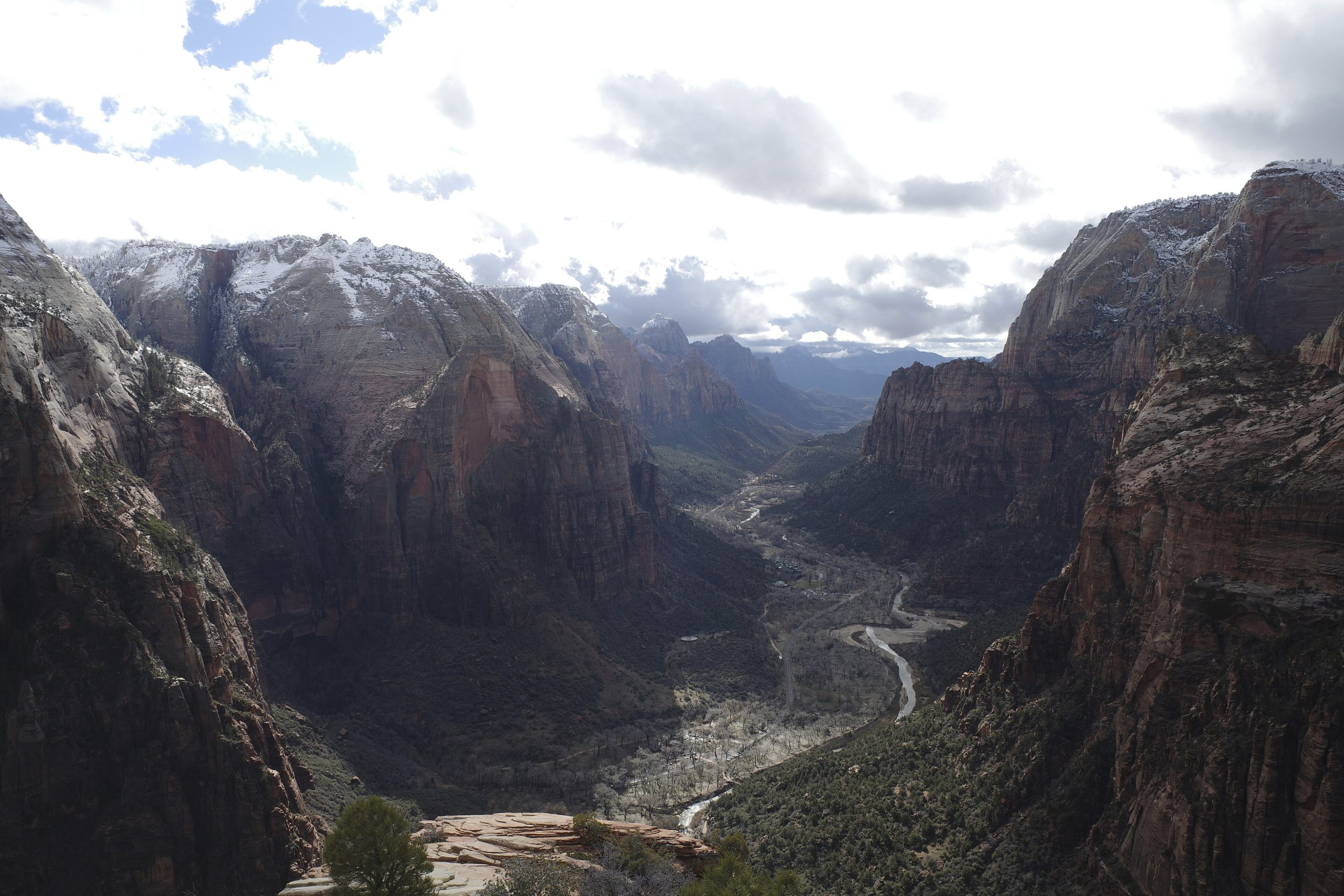
Zion National Park
Zion is a canyon of soaring sandstone cliffs, hanging gardens and the emerald-green Virgin River winding through it all, one of the most spectacular and beloved parks in the American Southwest. From the paved valley floor beneath 2,000-foot (600 m) walls to the vertigo-inducing spine of Angels Landing and the river-walking adventure of the Narrows, Zion packs world-class scenery and hiking into a single, dramatic gorge.
Fast facts
- Established: 1919
- Size: about 147,000 acres (595 km²) in southwest Utah
- Signature canyon: Zion Canyon, walled by cliffs up to 2,000 feet (600 m)
- Iconic hikes: Angels Landing and the Narrows
- Gateway: Springdale, Utah
- Managed by: National Park Service
The landscape
The Virgin River has cut Zion Canyon deep into the Colorado Plateau, exposing towering walls of Navajo sandstone streaked red, cream and pink. Springs seep from the cliffs to nourish hanging gardens, cottonwoods line the river, and the terrain climbs from desert canyon floor to high plateau. Beyond the main canyon lie slot canyons, the high country of Kolob, and habitat for bighorn sheep, mule deer and California condors.
Best time to go
Spring and fall offer the most comfortable hiking and beautiful light, with spring bringing high water and fall pleasant temperatures. Summer is hot and crowded, with monsoon storms raising serious flash-flood danger in the slot canyons. Winter is quiet and cold, sometimes snowy, with the shuttle often not running and a peaceful, uncrowded canyon.
Getting there and around
The park is reached via SR-9 with the main entrance at Springdale. For most of the year private vehicles cannot drive up Zion Canyon, a mandatory, efficient shuttle serves the canyon stops instead, so plan around it. The scenic Zion–Mount Carmel Highway and its tunnel offer a spectacular drive through the east side.
Things to do
Hike the thrilling, permit-only Angels Landing for its knife-edge finale, wade the Virgin River through the soaring Narrows, and walk gentler paths to the Emerald Pools and the Riverside Walk. Canyoneer the slot canyons with a permit, drive the Mount Carmel Highway, and watch for condors soaring above the cliffs.
Staying safe
Flash floods are the deadly hazard here. Never enter the Narrows or a slot canyon when storms threaten, and always check the flash-flood forecast. Heat and dehydration are serious in summer, so carry ample water; Angels Landing and other routes have severe, exposed drop-offs; and the river runs cold with slippery footing, so plan and equip carefully.
Know before you go
A park pass is required, Angels Landing needs a permit via lottery, and canyoneering and backcountry trips need permits. Plan well ahead. The canyon shuttle is mandatory in season. This page is a general overview, not a live conditions report; always confirm current conditions, flash-flood forecasts, shuttle status and permits with the National Park Service before your trip.
- Coordinates
- 37.3228, -113.0457
- Magnetic declination
- 10.6° E (2026)
Set this declination on your compass, then align it to the map's north lines; it is the angle between true north and magnetic north, refreshed each year.
A spread of the park’s main places shows straight away, and the rest appear as you zoom in. You can also search above, or pick any place from the lists below, and the map will go to it.
Getting there 7
Park entrances
Ranger stations
On the trail 58
Trailheads
Campgrounds
Picnic sites
Sights 54
Viewpoints
Waterfalls
Point of interests
Peaks 30
Map data comes from third-party sources and may be incomplete or out of date, so carry a current official map (terms).
- Best seasons
- Spring, Fall
- Difficulty
- Easy to strenuous
- Access / trailheads
- In southwest Utah via SR-9; the main entrance is at Springdale. A mandatory shuttle serves Zion Canyon most of the year. Nearest hub is St. George.
- Water
- Water at the visitor center and Grotto; carry ample water and treat river water.
- Cell / satellite coverage
- Little to no cell service in the canyons. Carry a map and check flash-flood forecasts.
- Nearest ranger / SAR / emergency
- Contact park rangers; life-threatening emergencies: 911.
- Permits & regulations
- Per-vehicle entry fee (America the Beautiful pass accepted); Angels Landing requires a permit via lottery, and canyoneering and backcountry trips need permits. A shuttle is mandatory on the canyon road in season.
- Leave No Trace
- Stay on trails and durable rock, pack out all waste (including in the Narrows), and follow Leave No Trace.
January
- Below-freezing nights
February
March
April
May
- Day-to-night swing of 31°F (17°C)
June
- Hot days
- Day-to-night swing of 33°F (18°C)
July
- Extreme daytime heat
- Day-to-night swing of 30°F (17°C)
August
- Hot days
September This month
- Hot days
- Day-to-night swing of 30°F (17°C)
October
November
December
- Below-freezing nights
What to bring depends on your trip: how long you’re out, where you sleep, and how far you go from the road. The planner builds the list for yours.
Plan a trip here →Averages for 1991–2020 from NOAA U.S. Climate Normals, measured at the Zion National Park station, 5 miles (8 km) away at 4,038 feet (1,231 m). Conditions change with elevation: expect it colder higher up.