Garmin GPSMAP 65s review: multi-band accuracy on AA batteries
Steep valleys, canyon walls and heavy tree cover are where a handheld GPS is most useful and where its position is least reliable, because satellite signals bounce off rock and trunks before they reach the receiver. The GPSMAP 65s is a mid-priced Garmin handheld with multi-band reception, the technology that corrects for those reflected signals, and it runs on two AA batteries that you can replace in the field.
Quick take
A multi-band handheld for people who work or travel in difficult terrain and want batteries they can swap in the field. The GPSMAP 65s has the same class of reception as the flagship GPSMAP 67, preloaded topo maps, a 3-axis compass and a barometric altimeter. The trade is a 16-hour battery life, a lower-resolution screen and no satellite imagery. Choose it when accuracy under trees and between rock walls matters more than a large screen.
What it does
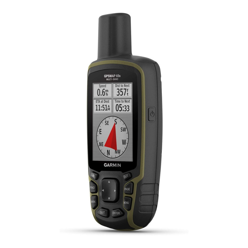
The GPSMAP 65s is a button-operated handheld with a 2.6-inch (6.6 cm) colour screen that stays readable in direct sun. It receives GPS, GLONASS, Galileo, QZSS and IRNSS satellites, and it listens to each on two frequencies at once. A single-band receiver has little ability to tell a direct signal from one that has bounced off a cliff or a wet trunk; a multi-band receiver compares the two frequencies and removes most of that error. In open country the gain is small; in a canyon, a gorge or dense forest the recorded track stays much closer to the trail.
It comes with routable TopoActive maps and, in the United States, a federal public land map that shows park, forest and wilderness boundaries. There is 16 GB of internal memory and a microSD slot for more maps. The “s” in the name stands for sensors: a tilt-compensated 3-axis compass that reads your heading while you stand still, and a barometric altimeter for elevation and pressure trends. The plain GPSMAP 65 has neither.
The unit stores 5,000 waypoints and 200 routes, pairs by Bluetooth with the Garmin Explore app to move tracks and waypoints to and from a phone, and works with Garmin’s free BaseCamp software on a computer. No subscription is needed for any of it. It is rated IPX7, which covers immersion to 3 feet (1 m) for 30 minutes, and the buttons work with gloves on.
Battery life, and why AA cells matter
Two AA batteries run the GPSMAP 65s for up to 16 hours. That is about two full days of walking, far short of the 182 hours of the rechargeable GPSMAP 67, and it is the main compromise of this model.
What you get in return is a power supply that does not depend on recharging. A set of spare lithium AAs weighs about an ounce (30 g), keeps its charge for years in a pack, and works in cold that cuts the capacity of a rechargeable pack. On a week-long trip, carry one spare pair for every two days of full-time tracking, or turn the unit on only when you need a position and a pair will last far longer. Use lithium or rechargeable NiMH cells; alkalines fade quickly in the cold.
What verified buyers say
Across verified-purchase reviews, the same points come up:
- Accurate, and quick to find satellites. The most repeated praise. Owners report positions good to about 6 feet (2 m), a fast first fix, and far less drift under trees than older handhelds.
- AA batteries are a reason to buy it. Several chose it over the rechargeable models so they could carry spares.
- Well built and waterproof in heavy rain. Long-time Garmin users call it robust, use it in downpours, and like the carabiner clip that comes in the box.
- Used for work as well as hiking. Soil sampling, archaeological survey and teaching scouts to navigate all come up, along with hikers who carry it to save their phone battery for emergencies.
- The menus are dated. The most common complaint. Finding a setting means scrolling with buttons through an interface that has changed little in over a decade, and the printed manual is short.
- The screen is coarse. Text and map detail look grainy beside a phone or a newer handheld.
- Garmin’s software takes patience. Updating maps and planning routes involves several separate apps, and one buyer found the full map update would not fit without a microSD card.
- Topo maps of the Americas, no aerial photos. Buyers who wanted satellite imagery, or who took the unit overseas, had to look elsewhere or pay for more maps.
Worth knowing
This is an older design with a current receiver. The screen is 160 x 240 pixels, which is coarse beside the GPSMAP 67, so fine contour detail takes more zooming. Data transfer is by mini-USB, a connector few other devices still use, so the cable in the box is one to keep. Garmin’s satellite imagery now downloads over Wi-Fi, which the 65s does not have, so plan on topo maps only. The low-battery warning can appear early; set the battery type in the menu to match your cells so the gauge reads correctly. Fit a microSD card before the first map update, because the full update may not fit in the internal memory, and raise the map detail setting, which is low out of the box. As with other Garmin handhelds, allow an evening to learn the menus before the first trip.
Who it is for
The GPSMAP 65s is for hunters, field workers, search volunteers and hikers who travel in canyons, steep forest or gorges and need a position they can rely on there, with batteries they can replace from a pocket. It suits trips where no power bank is carried, and winter use where a rechargeable pack loses capacity.
If your routes are mostly on open trails, the eTrex 32x gives you colour topo maps and the same sensors for less money and runs longer on its AAs. If you want the larger screen, satellite imagery and a week of battery, move up to the GPSMAP 67. If you only need to record a track and find the way back, the eTrex SE is the inexpensive choice. A GPS of any kind is carried with a map and a compass such as the Suunto M-3, and our guide to map and compass navigation covers using them together.
Specs at a glance
- Screen2.6″ (6.6 cm) colour, sunlight-readable
- Receptionmulti-band, GPS, GLONASS, Galileo, QZSS, IRNSS
- Mapsroutable TopoActive, microSD slot
- Sensors3-axis compass, barometric altimeter
- Batteryup to 16 h, 2×AA
- Water ratingIPX7
- Listed weight7.7 oz (217 g) · with batteries
- Best forcanyons, steep forest, field work, winter
Wilderness Experts is reader-supported. As an Amazon Associate we earn from qualifying purchases; when you buy through links on our site we may earn a commission at no extra cost to you. It never changes what we recommend.
The Verdict
The Garmin GPSMAP 65s puts multi-band accuracy into a handheld that runs on AA batteries. It holds an accurate position in canyons and under heavy canopy, carries topo maps, a compass and an altimeter, and needs no subscription. The screen is coarse, the battery life is 16 hours and there is no satellite imagery. For difficult terrain, cold weather and long trips without a way to recharge, it is a sound choice. For open trails the eTrex 32x costs less, and for the best screen and battery the GPSMAP 67 is the step up. To call for help where there is no cell coverage, add a satellite communicator such as the inReach Messenger.