

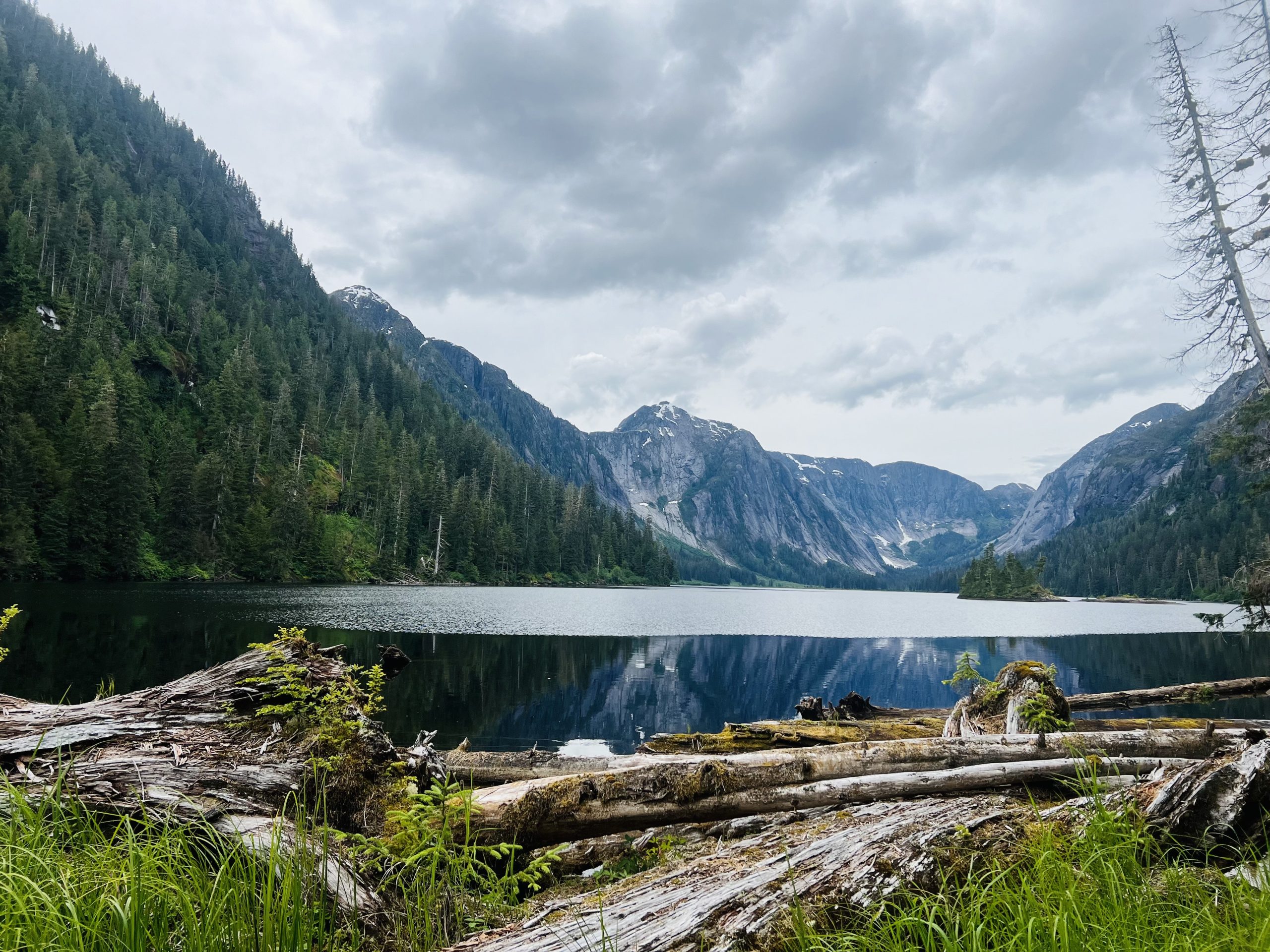
Misty Fjords National Monument
Misty Fjords is a wilderness of sheer granite fjords, waterfalls and rainforest east of Ketchikan in southeast Alaska, reached only by boat or floatplane. Most visitors see it on a flightseeing or boat tour from town, and paddlers and hikers go deeper with public-use cabins, shelters and sea kayak routes.
Fast facts
- Established: 1978; designated wilderness in 1980
- Size: about 2.3 million acres (9,300 km²), most of it the largest wilderness in Tongass National Forest
- Waterway: Behm Canal, more than 100 miles (160 km) long
- Facilities: 13 public-use cabins, several three-sided shelters and about 20 miles (32 km) of trail
- Gateway: Ketchikan, Alaska
- Managed by: the Forest Service (Tongass National Forest)
The landscape
Glaciers carved the fjords deep into granite, leaving cliffs that rise thousands of feet straight from the water, as at Punchbowl Cove in Rudyerd Bay. Waterfalls pour off the walls, and temperate rainforest of spruce, hemlock and cedar grows wherever it can take hold. Brown and black bears, mountain goats, whales and seals live here. It is one of the wettest places in North America, and low cloud and mist are the usual weather.
Best time to go
May to September. June to August is warmest and has the most daylight, though rain is likely on any day. Fall brings heavy rain and storms, and winter trips are rare.
Getting there and around
There are no roads into the monument. Floatplanes fly from Ketchikan to the fjords and lakes, and tour boats and water taxis run up Behm Canal in summer. Ketchikan has scheduled jet service from Seattle and Anchorage and is on the Alaska Marine Highway ferry route.
Things to do
Most visitors take a floatplane flight or a day cruise from Ketchikan into Rudyerd Bay and Punchbowl Cove; some flights land on a lake or fjord. Cruise ship passengers can do this in a single port day.
For a deeper trip, rent a public-use cabin and fly in for several days of fishing, hiking and quiet. Sea kayakers take a water taxi to Behm Canal and paddle for a week or more among the fjords, camping on beaches. Short, steep trails lead from saltwater to lakes, such as the trail from Punchbowl Cove to Punchbowl Lake.
Staying safe
The water is cold enough to cause hypothermia in minutes, so paddlers need immersion gear and rescue skills. Tides rise and fall about 20 feet (6 m), so camp well above the high-tide line and plan crossings around currents. Weather can ground floatplanes for days; carry extra food and plan flexible pickup dates. Bears are common: carry bear spray and store food in bear-resistant containers.
Know before you go
Public-use cabins are reserved in advance on Recreation.gov; shelters are first come, first served. Arrange floatplane or water taxi drop-offs and pickups before you go. This page is a general overview, not a live conditions report, so confirm cabin availability and conditions with the Forest Service before you go.
- Coordinates
- 55.5623, -130.7170
- Magnetic declination
- 17.3° E (2026)
Set this declination on your compass, then align it to the map's north lines; it is the angle between true north and magnetic north, refreshed each year.
How declination works, and how to navigate with a map and compass
A spread of the park’s main places shows straight away, and the rest appear as you zoom in. You can also search above, or pick any place from the lists below, and the map will go to it. Places in bold, marked , have a short description.
On the trail 11
Trailheads
Sights 82
Lakes
Points of interest
Peaks 27
Map data comes from third-party sources and may be incomplete or out of date, so carry a current official map (terms).
Looking for one of these closer to home?Destinations near me by trip type →
- Best seasons
- Summer (May to September)
- Difficulty
- Easy (tours) to strenuous (remote wilderness)
- Access / trailheads
- By floatplane or boat only, from Ketchikan. Tour boats and water taxis run up Behm Canal in summer.
- Water
- Plentiful in streams and lakes; treat all water.
- Cell / satellite coverage
- None. Carry a satellite messenger or VHF radio.
- Nearest ranger / SAR / emergency
- Emergencies: 911 or US Coast Guard on VHF channel 16. Ketchikan Misty Fjords Ranger District: 907-225-2148.
- Permits & regulations
- Public-use cabins by reservation on Recreation.gov; shelters first come, first served. No entrance fee.
- Leave No Trace
- Camp on beaches or durable sites above the tide line, store food in bear-resistant containers, and pack out all waste.
January
- Below-freezing nights
February
March
April
May
June
July
August
September
October This month
November
December
What to bring depends on your trip: how long you’re out, where you sleep, and how far you go from the road. The planner builds the list for yours.
Plan a trip here →Averages for 1991–2020 from NOAA U.S. Climate Normals, measured at the Beaver Falls station, 37 miles (60 km)60 km (37 miles) away at 35 feet (11 m)11 m (35 feet). Higher trails run colder, by about 3.5°F for every 1,000 ft (2°C per 300 m)2°C for every 300 m (3.5°F per 1,000 ft) of climb. Daylight runs from sunrise to sunset on the 15th, on the park’s own clock, for a level horizon. Valleys and slopes facing away from the sun are in shade earlier.
Nearby parks
Straight-line distance between park centres. Road distance is usually longer.
Looking for somewhere closer to home?
See every park and monument within a day’s drive of where you are.