

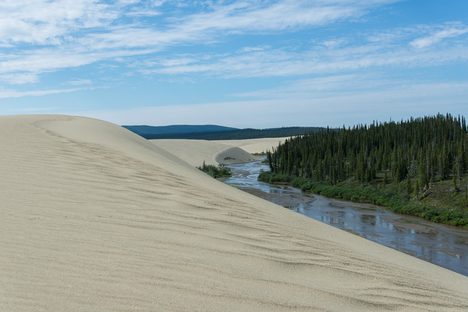
Kobuk Valley National Park
Just north of the Arctic Circle, Kobuk Valley hides one of Alaska’s strangest sights: a 25-square-mile field of sand dunes rising up to 100 feet (30 m), where summer temperatures can hit 100°F (38°C). There are no roads, no trails, no facilities and no rangers on-site across its 1.7 million acres (7,000 km²), just the Great Kobuk Sand Dunes, the winding Kobuk River, and one of the great caribou migrations of North America crossing straight through.
Fast facts
- Established: 1980, under the Alaska National Interest Lands Conservation Act
- Size: about 1.7 million acres (7,000 km²), roughly the size of Delaware
- Signature feature: the Great Kobuk Sand Dunes, up to 100 feet (30 m) tall
- Visitors: around 10,000 a year, one of the least-visited parks
- Location: northwestern Alaska, above the Arctic Circle
- Managed by: National Park Service
The landscape
The dunes are the showpiece, part of three dune systems covering more than 20,000 acres (80 km²), a desert-like anomaly amid the Arctic. Beyond them the land unfolds into the winding Kobuk River, rolling tundra, grass plains, muskeg, deltas and permafrost. The Onion Portage, a caribou crossing used by people for at least 9,000 years, threads through it all, and each fall the Western Arctic Caribou Herd streams across the sand in their thousands.
Best time to go
June through August is the practical season, the mildest weather, the most access, and up to 24 hours of daylight. It is also when the caribou make their dramatic migration through the valley. Spring and fall bring extreme cold and biting wind, and winter is best left to those with serious Arctic experience.
Getting there and around
There are no roads to Kobuk Valley. The only way in is a chartered flight, usually from Kotzebue. Once on the ground there are no trails or markers. You travel on foot, by boat or by fat bike across open tundra and dune, navigating by map, compass and GPS. Some operators offer guided fly-in trips with basic support, but most visitors arrange their own logistics.
Things to do
Hiking the sweeping dunes and camping under the midnight sun are the classic Kobuk experiences. The gentle Kobuk River invites boating and packrafting, fat biking on the sand has grown popular, and the wildlife, caribou above all, plus wolves, bears, Arctic foxes and migratory birds, is exceptional. For photographers, the dunes, river and light are endless material.
Staying safe
This is true wilderness with no amenities or rescue on-site, so plan for sudden weather, extreme temperatures and encounters with brown bears and wolves. Carry bear spray, store food properly, and stay alert. Summer mosquitoes can be intense, so bring repellent and protective clothing. Carry a satellite communicator or PLB, file a trip plan with someone outside the park, and pack all your own first aid, navigation and extra food.
Know before you go
Kobuk Valley is not a casual destination. You pack in everything and pack out all waste, with no trash facilities anywhere. Bring a reliable map, compass or GPS and know how to use them, and tread lightly on the fragile Arctic ecosystem. Take time to learn about the Inupiat people who have lived here for millennia. This page is a general overview, not a live conditions report; confirm current conditions and logistics with the National Park Service before your trip.
- Coordinates
- 67.3914, -159.0631
- Magnetic declination
- 9.8° E (2026)
Set this declination on your compass, then align it to the map's north lines; it is the angle between true north and magnetic north, refreshed each year.
A spread of the park’s main places shows straight away, and the rest appear as you zoom in. You can also search above, or pick any place from the lists below, and the map will go to it.
Sights 4
Heritage site
Point of interests
Peak
Map data comes from third-party sources and may be incomplete or out of date, so carry a current official map (terms).
- Best seasons
- Summer (June to August)
- Difficulty
- Strenuous (expedition only)
- Access / trailheads
- No roads reach the park. Access is by chartered flight, typically from Kotzebue. Inside, travel is off-trail on foot, by boat or by fat bike.
- Water
- The Kobuk River and tributaries; filter or treat all water.
- Cell / satellite coverage
- No cell service. Carry a satellite communicator or PLB and file a trip plan with someone outside the park.
- Nearest ranger / SAR / emergency
- No in-park services; coordinate through the NPS office in Kotzebue. Life-threatening emergencies: 911 (response may be many hours away).
- Permits & regulations
- No entrance fee and no permit system, but no facilities either. Visitors must be fully self-sufficient. There are no roads, trails, campgrounds or ranger stations on-site.
- Leave No Trace
- Pack in everything and pack out all waste; stay off fragile Arctic vegetation and dune systems and follow strict Leave No Trace.
January
- Below freezing all day
February
- Below freezing all day
March
- Below freezing all day
April
- Below freezing all day
May
- Below-freezing nights
June
July
August
September This month
October
- Below freezing all day
November
- Below freezing all day
December
- Below freezing all day
What to bring depends on your trip: how long you’re out, where you sleep, and how far you go from the road. The planner builds the list for yours.
Plan a trip here →Averages for 1991–2020 from NOAA U.S. Climate Normals, measured at the Kotzebue Airport station, 101 miles (163 km) away at 11 feet (3 m). That is the nearest station with long-term records, so treat these as a regional guide. Conditions change with elevation: expect it colder higher up.